History of Wan-Xin Railway
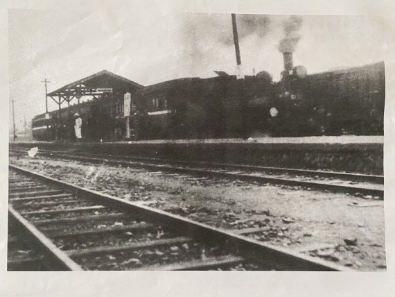
Wan-Xin Railway, which served the Xindian railroad branch line that traveled westward, ran from Wanhua to Xindian. It was constructed in 1921 (the 10th year of the Taisho era) by Taihoku Railway Company, which operated with private capital. Known as Taihoku Railway at the time, this railway started off from Wanhua Railway Station, traveling along Sections 1 to 3 of Tingzhou Road, crossing Keelung Road and going straight from Alley 23 of Section 4 of Tingzhou Road, entering the end of Alley 150 of Section 5 of Roosevelt Road in front of the present-day Gongguan Campus of National Taiwan Normal University and leaving from the head of the alley, and moving along Roosevelt Road to reach Xindian. The railway originally measured 10.4 km in length; in 1931, it was extended by 300 m to 10.7 km to serve the County Office in Xindian.
During the Japanese colonial period, the railway stopped at 16 stations: Kuchaing (a freight station), Babacho, Hotarubashi, Koteicho, Senkobyo, Suigenchi, Kokan, Jyugofun, Seibinkaisha-mae, Keibi, Ershizhang, Taihei Kogakko-mae, Taiheirin, Shichichori, Shinten, and Gunyakusho-mae. After World War II, the railway was operated by Taiwan Railways Administration (TRA) as a public business. Now it served 11 stations: Kuchaing (a freight station), Hoping (formerly “Babacho”), Yingchiao, Kuting (formerly “Koteicho”), Shuiyuan Ti, Kungkuan, Wanlung (renamed from “Jyugofu” in 1955), Chingmei (formerly “Keibei”), Ta Pinglin, Chichang, and Hsintien. The railway provided the main means of transportation to travel from Wenshan and Xindian, and it was frequently used by people in Taipei to visit Bitan until the 1960s. However, as road transportation infrastructures and coal production plunged, TRA could no longer handle its financial deficits because of the railway. The use of the railway also led to national defense concerns. As a result, it was decommissioned in 1965, officially ending its 44-year service. All the stations it served and its rail tracks were immediately removed. The scenes of trains running in Jingmei are only left in the memory of local elders.
Jingmei Railway Station
A major station of Wan-Xin Railway,Jingmei Railway Station was located at the junction of Section 6 of Roosevelt Road and Cheqian Road. It was a wooden bungalow with two platforms and six tracks. On the front left and right of the station was a facility where coal deposits delivered by push cars from Shiding, Shenkeng, and Muzha were stored. Right in front of the station was Cheqian Road, which measured 83.3 m in length, making it the shortest road in Taipei at the time. At the junction of the right of Cheqian Road’s end and Jingwen Street was formerly the Jingmei Highway Bureau and Bus Terminal.
Jyugofu Railway Station
Jyugofu Railway Station was a simple station of Wan-Xin Railway that had no ticket booths. It was renamed “Wanlung” in 1955. The station lay in front of today’s Wanmei Building at the intersection of the old path of Jinglong Street and Sections 5 and 6 of Roosevelt Road. Wanmei Building was where a coal storage facility once operated and collected coal deposits sent from Yongfeng. Xinyi, and Wanlong mines by push cars traveling along Jinglong Street.

最新自 何文賢 / He Wen-hsien
- 1960年代的景美菜市場
- 己亥年(108年)景美聯合遶境
- 壬辰年(民國101年)景美集應廟迎香慶典
- 壬辰年(民國101年)景美聯合遶境慶典
- 文山興安宮
- 古亭地政事務所
- 未有大樓前的景美街景
- 由景文街看車前路
- 車前路地貌的改變
- 辛卯年(民國100年)北投集應廟至景美迎回保儀
- 原車前路上順泰玩具食品行
- 高選風遺墨
- 景文街林鶴年醫院舊宅
- 景美集應廟豬公祭典(一)
- 景美舊橋封橋待拆除
- 開道碑重置揭幕
- 瑠公圳舊道與新道會合點
- 興隆市場
- 1970年以前景美的工廠及公營機構
- 1980年以後景美的工廠及公營機構
- Liugong Bridge: the First Reinforced-Concrete Bridge in Taiwan
- Expected Changes for the Landscape of Jingmei After 2020
- Landscape of Jingmei during 2000–2020
- Landscape of Jingmei during 1980–2000
- Landscape of Jingmei during 1960–1980
- Landscape of Jingmei before 1960
- The Stealthy Wansheng River
- Turning Jingmei River Channels into Parks
- A Potential Archeological Site of Shiwufen
- Xingfu Village Monument
- Earth God Temple in Jingmei
- Liugongjun and Wooden Trough Bridge
- History of Jingmei Bridge
- Coal Mining in Wenshan District
- Important Infrastructures in Wenshan District from the Past
- Changes in Jingmei’s Geography and Road Infrastructure
- History of Jingmei
- 霧裡薛圳圳路
- 景美街1號與2號距離遠
- 景美行政變遷
- 景美老街拱形騎樓元素
- 都更下的景美街困境
- 2000年至2020年景美地景變遷
- 1960年以前景美地景樣貌
- 1960年至1980年景美地景變遷
- 1980年至2000年景美地景變遷
- 2020年後景美地景變遷的期待
- 景美街商業土地使用分區
- 原貌仍在的泰興染織廠
- 中農化工廠基地變遷
- 1980年以後景美的工廠及公營機構
- 1970年以前景美的工廠及公營機構
- 興福庄「建塚記念碑」
- 金獎外觀興隆市場
- 臺北花木批發市場
- 疑似十五份遺址
- 會元洞清水祖師廟
- 景美福興宮
- 景美瑠公圳暨成巷道
- 景美忠勤三莊新面向
- 景美「賴氏萬壽塔」
- 頂公館福德宮
- 消失的興福庄浚溝修路石碑
- 和伯公紀念會館
- 台北江西會館及萬壽宮
- 在興隆路的台北畜產運銷公司
- 在景美的古亭地政事務所
- 文山興安宮
- 文山溪洲福德宮
- 三福街古道
- 十五分火車站
- 十五分庄舊地名
- 木柵集應廟保儀尊王巡境貓空
- 甲午年(103)木柵集應廟巡境慶典
- 景美集應廟豬公祭典
- 仙跡岩拾遺
- 仙跡岩的民間信仰
- 仙跡岩舊八景
- 龍吃水的地理景觀
- 圳後山的圖根點
- 景美山的三角點
- 百年金龜樹生病了
- 景美其他的老樹
- 景行公園的老樹
- 景美養工處老樹
- 巷內的魯花樹
- 興安宮的老榕樹
- 景豐街的老樹
- 萬有公園的老樹
- 萬和公園的老樹
- 景美國中的老樹
- 景美國小附近老樹
- 景美國小的老樹
- 萬新鐵路的歷史
- 景美聖方濟沙勿略堂
- 景美的西方教會彙總
- 味自慢居酒屋
- 義興樓食堂
- 景美的春燕
- 萬盛溪舊溪床旁的春燕
- 你目前位置:
-
首頁

-
Wenshan Studies
- History of Wan-Xin Railway