The Stealthy Wansheng River
It might be hard to believe that a river used to wind on both sides of Xinglong Road in the urbanized Wenshan District, yet the path of the river is clearly visible on the Taiwan map of 1921. This river is called Wansheng River.
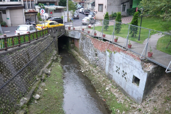
Speaking of what Wansheng River looks like today, you can see open channels in the two branches of the upstream section of the river. The river’s path remains largely clear as ever, but the path has a varied landscape that includes a strip of vacant land, unknown alleys and lanes, illegally constructed buildings, and building land for development. In addition, there are two bridges halfway along the path. One is Xian Tong Bridge, but only its tablet survives. The other is Wansheng Bridge, which still remains fully intact at its original location. Walk down Alleys 92 and 97 on both sides of Section 5 of Roosevelt Road, and you have two 10 meter-long open channels springing up in your eyes. Then shift to the front of Treasure Hill; the gurgling waters flow into Xindian River, a sign of Wansheng River still doing its share of work to discharge water for the local urban region.
In the past, Jingmei consisted of two main villages: Xingfu Village (locally known as Shiwufen Village) in the east and Wansheng Village in the west. Wansheng River is a natural catchment area surrounded by mountains in Nangang and their extensions. The northern branch of the river originates from Zhongbu Mountain, and the southern one from Jingmei Mountain. When both branches meet, they wind along Xingfu Village and terminate at Wansheng Village (nowadays the Gongguan Campus of National Taiwan Normal University) to flow into Jingmei River—hence the name “Wansheng River.” While the old channels of Jingmei River (which have been repurposed into several long-strip parks—Wanhe Park No. 1, 2, and 3 and Wannian Park No. 1, 2, and 3) were decommissioned after levees were installed as part of urban development, Wansheng River continues its path northward from the channels in the front of the campus, flowing into Xindian River before Treasure Hill, and this explains why the former river is a branch of the latter.
It is said that early residents on both sides of Xinglong Road would cross over Wansheng River for convenience’s sake rather than taking a detour to use a bridge. In the agrarian Taiwan, the river not just discharged water but also supplied water to crop fields. Moreover, its bed was once covered with so much silt that “droughts hit in summer and floods in autumn,” making life difficult for locals. In 1926 (the 1st year of the Showa era), the river’s bed was dredged and paved with pebbles—an important public works project that ended with a commemorative monument.
However, since Wansheng River, which had been collecting and discharging water, was capped, rainwater could not be drained, in the event of sudden rains, as quickly as it used to be, thus leading to floods. A few years ago, this was particularly the case where the river’s northern and southern branches meet (near the gas station at the junction of Xinlong Road and Xinhai Road), because the rainwater discharged from the hills in the north and south could not be timely removed. The proneness of the juncture of the river’s northern and southern branches to floods was not solved until the Taipei City government built a detention basin at each of the branches, opened two drainage channels at the respective cols of the northern and southern hills, and furnished Jingmei Wastewater Pumping Station with more water suction pumps.
Wansheng River was integral to Xingfu Village and Wansheng Village. As extreme weather conditions continue to prevail, rivers can prevent floods for urban areas and mitigate the urban heat island effect. Preserving the old channels of Wansheng River allows us to retain the public memory of the past and contributes to a varied landscape.

最新自 何文賢 / He Wen-hsien
- 1960年代的景美菜市場
- 己亥年(108年)景美聯合遶境
- 壬辰年(民國101年)景美集應廟迎香慶典
- 壬辰年(民國101年)景美聯合遶境慶典
- 文山興安宮
- 古亭地政事務所
- 未有大樓前的景美街景
- 由景文街看車前路
- 車前路地貌的改變
- 辛卯年(民國100年)北投集應廟至景美迎回保儀
- 原車前路上順泰玩具食品行
- 高選風遺墨
- 景文街林鶴年醫院舊宅
- 景美集應廟豬公祭典(一)
- 景美舊橋封橋待拆除
- 開道碑重置揭幕
- 瑠公圳舊道與新道會合點
- 興隆市場
- 1970年以前景美的工廠及公營機構
- 1980年以後景美的工廠及公營機構
- Liugong Bridge: the First Reinforced-Concrete Bridge in Taiwan
- Expected Changes for the Landscape of Jingmei After 2020
- Landscape of Jingmei during 2000–2020
- Landscape of Jingmei during 1980–2000
- Landscape of Jingmei during 1960–1980
- Landscape of Jingmei before 1960
- Turning Jingmei River Channels into Parks
- A Potential Archeological Site of Shiwufen
- Xingfu Village Monument
- Earth God Temple in Jingmei
- History of Wan-Xin Railway
- Liugongjun and Wooden Trough Bridge
- History of Jingmei Bridge
- Coal Mining in Wenshan District
- Important Infrastructures in Wenshan District from the Past
- Changes in Jingmei’s Geography and Road Infrastructure
- History of Jingmei
- 霧裡薛圳圳路
- 景美街1號與2號距離遠
- 景美行政變遷
- 景美老街拱形騎樓元素
- 都更下的景美街困境
- 2000年至2020年景美地景變遷
- 1960年以前景美地景樣貌
- 1960年至1980年景美地景變遷
- 1980年至2000年景美地景變遷
- 2020年後景美地景變遷的期待
- 景美街商業土地使用分區
- 原貌仍在的泰興染織廠
- 中農化工廠基地變遷
- 1980年以後景美的工廠及公營機構
- 1970年以前景美的工廠及公營機構
- 興福庄「建塚記念碑」
- 金獎外觀興隆市場
- 臺北花木批發市場
- 疑似十五份遺址
- 會元洞清水祖師廟
- 景美福興宮
- 景美瑠公圳暨成巷道
- 景美忠勤三莊新面向
- 景美「賴氏萬壽塔」
- 頂公館福德宮
- 消失的興福庄浚溝修路石碑
- 和伯公紀念會館
- 台北江西會館及萬壽宮
- 在興隆路的台北畜產運銷公司
- 在景美的古亭地政事務所
- 文山興安宮
- 文山溪洲福德宮
- 三福街古道
- 十五分火車站
- 十五分庄舊地名
- 木柵集應廟保儀尊王巡境貓空
- 甲午年(103)木柵集應廟巡境慶典
- 景美集應廟豬公祭典
- 仙跡岩拾遺
- 仙跡岩的民間信仰
- 仙跡岩舊八景
- 龍吃水的地理景觀
- 圳後山的圖根點
- 景美山的三角點
- 百年金龜樹生病了
- 景美其他的老樹
- 景行公園的老樹
- 景美養工處老樹
- 巷內的魯花樹
- 興安宮的老榕樹
- 景豐街的老樹
- 萬有公園的老樹
- 萬和公園的老樹
- 景美國中的老樹
- 景美國小附近老樹
- 景美國小的老樹
- 萬新鐵路的歷史
- 景美聖方濟沙勿略堂
- 景美的西方教會彙總
- 味自慢居酒屋
- 義興樓食堂
- 景美的春燕
- 萬盛溪舊溪床旁的春燕


