Turning Jingmei River Channels into Parks
Outside the levees along Jingmei River in Jingmei are three long-strip parks: Jingmei Park (formerly “Jingmei Riverside Park”) in the neighborhood of Yuying Street and Wanqing Street, Wanhe Park No. 1, 2, and 3 near the end of Wanlong Street, and Wannian Park No. 1, 2, and 3 between Wanfu Elementary School and Section 4 of Tingzhou Road. Most parks in Taiwan have a quasi-square shape; few have a shape of a long strip. This makes the three aforementioned parks worth exploring.
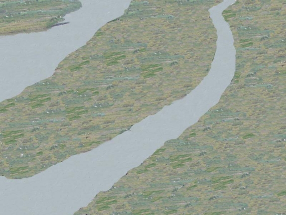
On the Taiwan map of 1921, produced during the Japanese colonial period, Jingmei River forms into two diversions when it flows to Beixin Bridge (which crosses Taipei and terminates in Xindian). In the middle of the diversions are two shoals in the vicinity of Xizhikou (around the end of Wanqing Street); one lies before Xizhikou and is called “Dingxizhou” and the other lies close to Dinggonguan (nowadays Gongguan) and is called “Xiaxizhou.” When early settlers traveled to Jingmei via Tamsui River and Xindian River, they went ashore Jingmei River between both shoals and named this place “Xizhikou” (Jingmei River converges into the entrance to Xindian River, hence the name). Levees would then be put up along Jingmei River, which was prone to overflowing and causing a flood. The levees were built to enclose Dingxizhou, with a diversion on its right kept outside of them, and they stood on the left side of Xiaxizhou (some settlers had lived there before the construction), keeping out the shoal and a diversion on its right side. By now, the diversions outside the levees received no river water, and after they dried up, they would be filled with soil, planted with trees, and eventually rebuilt into long-strip parks.
Xiaxizhou had already seen residence before the levees were put up. Today’s Xizhou Street leads to Xiaxizhou, and because its route includes an old channel of Jingmei River, there used to be a bridge halfway. Xiazhizhou is an area of land located between Section 4 of Tingzhou Road and the levees; it spans National Taiwan Normal University’s Gongguan Campus and high-rise buildings constructed from military villages.

最新自 何文賢 / He Wen-hsien
- 1960年代的景美菜市場
- 己亥年(108年)景美聯合遶境
- 壬辰年(民國101年)景美集應廟迎香慶典
- 壬辰年(民國101年)景美聯合遶境慶典
- 文山興安宮
- 古亭地政事務所
- 未有大樓前的景美街景
- 由景文街看車前路
- 車前路地貌的改變
- 辛卯年(民國100年)北投集應廟至景美迎回保儀
- 原車前路上順泰玩具食品行
- 高選風遺墨
- 景文街林鶴年醫院舊宅
- 景美集應廟豬公祭典(一)
- 景美舊橋封橋待拆除
- 開道碑重置揭幕
- 瑠公圳舊道與新道會合點
- 興隆市場
- 1970年以前景美的工廠及公營機構
- 1980年以後景美的工廠及公營機構
- Liugong Bridge: the First Reinforced-Concrete Bridge in Taiwan
- Expected Changes for the Landscape of Jingmei After 2020
- Landscape of Jingmei during 2000–2020
- Landscape of Jingmei during 1980–2000
- Landscape of Jingmei during 1960–1980
- Landscape of Jingmei before 1960
- The Stealthy Wansheng River
- A Potential Archeological Site of Shiwufen
- Xingfu Village Monument
- Earth God Temple in Jingmei
- History of Wan-Xin Railway
- Liugongjun and Wooden Trough Bridge
- History of Jingmei Bridge
- Coal Mining in Wenshan District
- Important Infrastructures in Wenshan District from the Past
- Changes in Jingmei’s Geography and Road Infrastructure
- History of Jingmei
- 霧裡薛圳圳路
- 景美街1號與2號距離遠
- 景美行政變遷
- 景美老街拱形騎樓元素
- 都更下的景美街困境
- 2000年至2020年景美地景變遷
- 1960年以前景美地景樣貌
- 1960年至1980年景美地景變遷
- 1980年至2000年景美地景變遷
- 2020年後景美地景變遷的期待
- 景美街商業土地使用分區
- 原貌仍在的泰興染織廠
- 中農化工廠基地變遷
- 1980年以後景美的工廠及公營機構
- 1970年以前景美的工廠及公營機構
- 興福庄「建塚記念碑」
- 金獎外觀興隆市場
- 臺北花木批發市場
- 疑似十五份遺址
- 會元洞清水祖師廟
- 景美福興宮
- 景美瑠公圳暨成巷道
- 景美忠勤三莊新面向
- 景美「賴氏萬壽塔」
- 頂公館福德宮
- 消失的興福庄浚溝修路石碑
- 和伯公紀念會館
- 台北江西會館及萬壽宮
- 在興隆路的台北畜產運銷公司
- 在景美的古亭地政事務所
- 文山興安宮
- 文山溪洲福德宮
- 三福街古道
- 十五分火車站
- 十五分庄舊地名
- 木柵集應廟保儀尊王巡境貓空
- 甲午年(103)木柵集應廟巡境慶典
- 景美集應廟豬公祭典
- 仙跡岩拾遺
- 仙跡岩的民間信仰
- 仙跡岩舊八景
- 龍吃水的地理景觀
- 圳後山的圖根點
- 景美山的三角點
- 百年金龜樹生病了
- 景美其他的老樹
- 景行公園的老樹
- 景美養工處老樹
- 巷內的魯花樹
- 興安宮的老榕樹
- 景豐街的老樹
- 萬有公園的老樹
- 萬和公園的老樹
- 景美國中的老樹
- 景美國小附近老樹
- 景美國小的老樹
- 萬新鐵路的歷史
- 景美聖方濟沙勿略堂
- 景美的西方教會彙總
- 味自慢居酒屋
- 義興樓食堂
- 景美的春燕
- 萬盛溪舊溪床旁的春燕
- 你目前位置:
-
首頁

-
Wenshan Studies
- Turning Jingmei River Channels into Parks