Muzha Old Street and Landmarks Nearby
-
Development of the Muzha Old Street
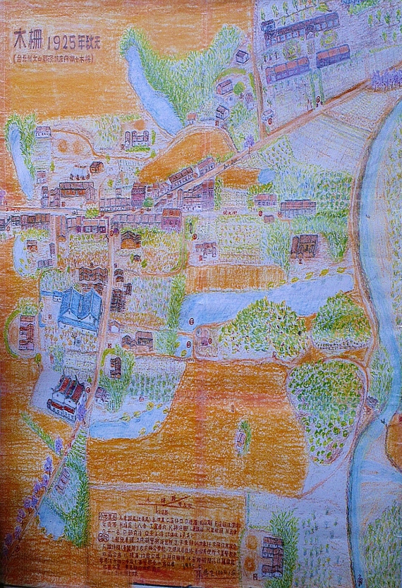
In around 1700 (during the reign of Emperors Kangxi and Qianlong of the Qing Dynasty), immigrants from provinces of Fujian and Guangdong seeking to settle in the Taipei Basin first entered Taiwan from Tamsui and traveled to Tamsui River, Xindian River, and Jingmei River to establish their footholds. By 1745 (an early year of the Qianlong era), they had spread to Muzha, which would be converted into a commercial street in 1800 (during the reign of Emperors Jiaqin and Daoguang of the Qing Dynasty) and served as a midpoint between Shenkeng and Shiding that led to the upstream section of Jingmei River. After World War II, the Muzha Old Street spanned Section 3 of Muzha Road, Baoyi Road, and Section 1 of Zhinan Road; this geographical range can be depicted in a Taiwan map drawn in 1921.
-
Overview of the name “Muzha”
-
Muzha and Neihu: When early immigrants settled in Muzha, they needed to build a defense against attacks from indigenous people. Led by the Zhang clan Dapi, the immigrants fortified their houses and built a lookout on Gengliao Mountain. They also put up wooden fences stretching from the head of the present-day Wanshou Bridge, Kaiyuan Street, and the head of Daonan Bridge, to the river banks around Datieliao—hence the name “Muzha.” Exactly when the fences were installed and removed cannot be determined, but such an event is inscribed on a monument for “the former site of Muzha” erected at the head of Daonan Bridge on the right bank of the present-day Jingmei River. The name “Muzha” made its first appearance as “Muzha Village” in The Annals of Tamsui Subprefecture in 1812 (the 17th year of the Jiaqing era). Muzha was then part of Fort Chuansanm, and it was the name of a village, not an administrative region. Generally speaking, a place name appeared first in government documents; it attained the administrative status only when that place was developed to some extent or an important event occurred there. One case in point is the placement of Neihu by Muzha.
Ringed by mountains on three sides and split by Jingmei in the middle, Muzha has a landscape characterized by long and narrow river-valley plains in the east and west and several small basins. In Southern Min, “hu” refers to a basin within a mountain. Muzha was called “Neihu” between the Qing Dynasty and Japanese Colonial Period; officially, it was called “Neihu Village.”
-
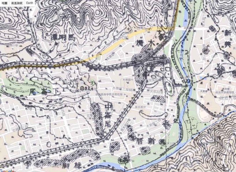
Gengliao and Gengliao Hill: At the junction of Section 1 of Zhinan Road and Muzha Road there used to be a small hill. On the hill, early residents built a lookout where their guards stayed on alert around the clock in case of any attack from indigenous people. A cabin was installed on the lookout for night watchmen to use; the cabin is popularly known as “Gengliao,” so the hill is called “Gengliao Hill.” The hill was flattened and replaced by a gas station in recent years, when Muzha Road and Muxin Road were widened and their levees refurbished.
-
Duchuantou (Head of the Ferry Port) and Duchuanxian (Ferry Alley): There used to be several ferry ports in Muzha. At the head of the present-day Daonan Bridge was the Head of the Ferry Port, which was the main ferry port. A small path stretching from the Head of the Ferry Port to Top Shops on Kaiyuan Street (spanning Alleys 56 and 96 of Section 1 of Zhinan Road) was the Ferry Alley. Top Shops were a neighborhood at the junction of Kaiyuan Street and Muxing Road where the first commercial establishments of the Muzha Old Street were based.
-
Datieliao: Around the middle of Section 2 of Muxin Road, there used to be ironmongery shops that crafted a variety of farming implements for land cultivation. So, that’s how the name “Datieliao” came into being. There is another story behind the origin of the name. According to the Zheng family in Muzha, their ancestor Zheng Ketie built a shack after he settled there; his shack was called “Tieliao” but later erroneously referred to as “Datieliao.”
-
Sirenwakou (Xiangpu): In front of the present-day National Chengchi University Gymnasium was Duchuantou (the Head of the Ferry Port), from which people could trek to the ferry port on the opposite side. The waters from Duchuantou to the port were so deep that many had died crossing from there, so Duchuantou is labeled as “Sirenwakou” (or the Port of the Deceased). Every year on Dragon Boat Festival, locals would hold dragon boat races for those who died in the waters. In addition, they would wrap up a God’s tour of inspection with dinner. Thus, Duchuantou is also known as “Xiangpu.”
-
Shizijiao: There used to be a persimmon garden planted by the early resident Zhang at the intersection of Baoyi Road and Zhinan Road. So, this place is called “Shizijiao.”
3. Important landmarks near Muzha Old Street
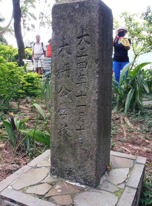
(1) Muzha Elementary School: Muzha Elementary School has been renamed multiple times. It was founded in 1906 (the 39th year of the Meiji era) as the Neiko Branch of Kengbe Public Elementary School (Muzha was under the administration of Neihu Village at the time) and became independent as Neihu Public Elementary School in 1909 (the 42nd year of the Meiji era). The school is now over a hundred years old.
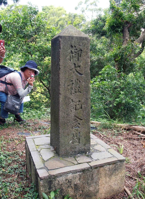
(2) Monument in Honor of Emperor Taisho: This monument stands on a small hill on the east side of Muzha Elementary School. It was erected to commemorate Japanese Emperor Taisho’s enthronement in November 1915 (the 4th year of the Taisho era), when the emperor finished a three-year wake for his deceased predecessor (a custom at the time) and all manner of celebratory events for this enthronement were held.
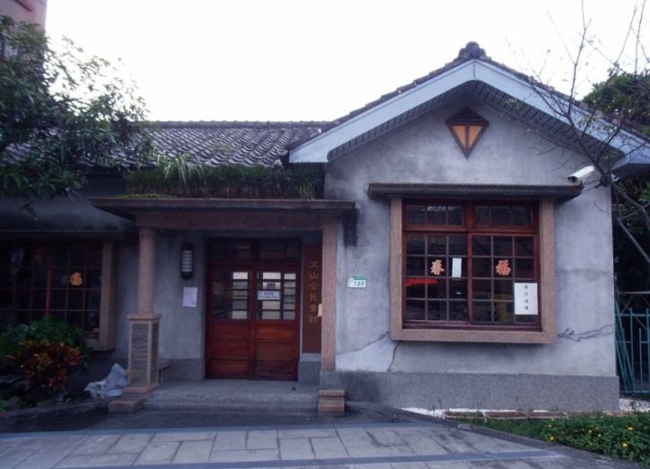
(3) Wenshan Public Assembly Hall: The hall sits on No. 189 of Section 3 of Muzha Road and on the right side of Muzha Elementary School. A Japanese-style bungalow built in 1927 (the 2nd year of Emperor Showa), it has a quaint, modest, and elegant appearance; its diamond-shaped windows can leave quite an impression. The hall originally provided sleeping and residential quarters for successive principals of Muzha Public School (nowadays Muzha Elementary School); it fell into disuse in 1982, when Principal Liu Shanming—its last resident—passed away. After having been abandoned for some time, this housing unit was remodeled as Wenshan Public Assembly Hall thanks to the hard work of locals. The hall was unveiled in October 2002 and has since re-connected with locals in historical and cultural terms.
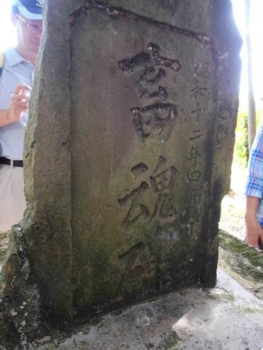
(4) Japanese Police Memorial Tablet: This tablet commemorates six Japanese police officers who were besieged and killed by an anti-Japanese crowd on December 31, 1895. It was erected on Gengliao Hill next to Muxin Road Bridge in August 1897 (the 30th year of the Meiji era). After Muxin Road was developed, with the hill flattened to make way for a gas station, the tablet was moved to Wenshan Park next to Wenshan District Administration Center. The inscription on the monument has since been painted over and rendered illegible.
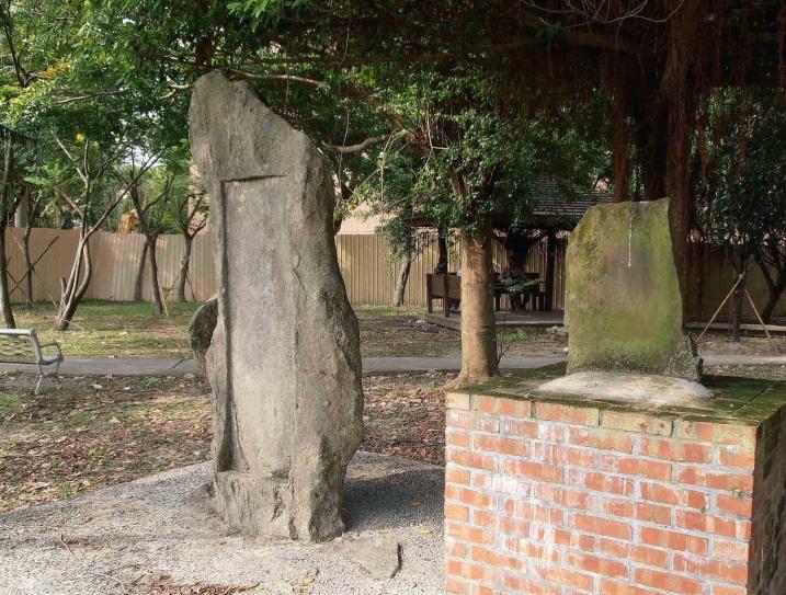
In the picture above: Japanese Police Memorial Tablet (the higher one on the left) and Slaughterhouse Spirit at one corner of Wenshan Park
(5) Slaughterhouse Spirit Tablet: This tablet was erected by Japanese near a slaughterhouse in Alley 14 of Section 1 of the present-day Zhinan Road in April 1937 (the 4th year of the Showa era) for the purposes of comforting the public’s mind and thanking pigs for their sacrifices. The slaughterhouse was built on a paddy field to prevent the howls of pigs being killed from disturbing local residents. As Muzha’s economy grew, the facility was moved away, with the tablet moved to Wenshan Park next to the Wenshan District Office.
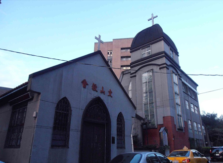
(6) Wenshan Church: The church is located in Kaiyun Street; its full name is the Presbyterian Church in Taiwan. In 1875 (the first year of the Guanxu era), Zhang Naihong, a tea farmer from Nanshan District of Muzha, found himself deeply touched by Rev. George Leslie MacKay’s missionary work and became a Christian during his travel through Quchi in Xindian. Zhang would go to church along with his family members and do crowdfunding to build chapels. The church witnessed how its members preached the Gospel through Muzha in the past. In 2019, it was registered as a cultural asset of Taipei City.
(7) Daonan Bridge: In the old days, boats were the only means of transportation to go from Muzha to Zhinan Temple or Maokong on the opposite side of Jingmei River. Later, Daonan Bridge, a suspension bridge, was built through collective financial support to make it more convenient for the pilgrims of Zhinan Temple to climb to a hill where they could worship Lu Dongbing (an immortal in folk tales), and to facilitate traffic to and from both sides of the river. In 1935 (the 10th year of the Showa era), the bridge was reconstructed as a more attractive arch reinforced-concrete bridge. As local traffic increased and a need was established to improve boat traffic in Jingmei River, it was rebuilt as a straight type in 1974, with pedestrian and bicycle paths furnished on its both sides, and has since been around in this format.

最新自 邱螢輝 / Chiu Ying-hui
- 石門與石門宮
- 高選鋒
- 開道碑的由來
- 開道碑流浪記
- 開道碑碑文
- 舊渡口-- 溪仔口
- 景美歷史沿革
- 景美街之頂街與下街
- 景美行政變遷表
- 景美地名由來
- 圳後與後圳
- 景美老街三座廟宇
- 十五分庄踏查報告
- 萬盛庄踏查—古亭地政事務所、萬和公園、溪洲街眷村
- 萬和里踏查活動紀錄
- 茶香環狀步道的人文景觀
- 永興廟福壽碑
- 從啟靈堂淺談無祀孤魂信仰
- 貓空的木炭窯
- 線上文史導覽 | 景美溪舊河道的變遷與昇華
- Jingmei Jiying Temple
- 「影像文山 留住記憶」邱螢輝
- 木柵老街踏查報告
- 103(甲午)年景美集應廟遶境慶典活動踏查報告
- 台灣傳統民居簡介
- 十五分庄踏查報告(二)
- 萬和里踏查活動紀錄 (一)
- 萬盛庄踏查—古亭地政事務所、萬和公園、溪洲街眷村
- 景美老街三座廟宇
- 你目前位置:
-
首頁

-
Wenshan Studies
- Muzha Old Street and Landmarks Nearby